Mapping UK ANPR Cameras
Hello,
I'm new, so still learning.
I'm coming from MapsMe where I have been mapping police ANPR cameras across the UK over several years now (with over 200 dots on the map now). These over 8000 (acc. to Wikipedia) usually small, black cameras, deliberately hard to see and in officially undisclosed locations and feed into a central database, thus creating motion profiles of individuals that are stored for a year.
To highlight this huse surveillance network, I wanted to crowd share and crowd source a map. That's something one can't do in MapsMe- but is it possible with OSM??
Sirorezka Tue 20 Jun 2023 4:09PM
Also check data identified by Mapillary: they use Computer Vision on top of photos uploaded from drivers:
Ed Loach Wed 21 Jun 2023 7:50AM
It looks like a few are already mapped. Checking the wiki it seems surveillance:type=ALPR is the recommended tag, so checking for alpr AND anpr at the UK taginfo site suggests there are probably almost 1000 mapped. This overpass query shows where the alpr tagged ones are.
Ed Loach Wed 21 Jun 2023 8:06AM
Having said that, I checked the one nearest me on the overpass map, and double checked it in Mapillary.
I would have tagged that as a speed camera (and perhaps with an enforcement relation) rather than an ANPR camera (though wouldn't know what an ANPR camera looks like). In fact it is also mapped as a speed camera, and in an enforcement relation. So checking Mapillary more carefully I spotted the ANPR camera (I assume) on a lamppost.
GBano Wed 21 Jun 2023 6:51PM
Well there is an ANPR on the street light here: https://www.mapillary.com/app/?pKey=825758188316261 but the Google image is clearer as you can tilt up better. Itâs hardly visible.
There is another one here on the lamp post: https://www.mapillary.com/app/?pKey=139067988259415
On the traffic lights here: https://www.mapillary.com/app/?pKey=286309776379362
And one off this roundabout!: https://www.mapillary.com/app/?pKey=1288031302032283
If the attachments come through, it will show a part of what I mapped, actually 800+ locations so far.
Typically those cameras have a steep angle towards a single lane rather than an overview position. And they are completely unmarked.
Usually they are located at motorway and roundabout exits if outside cities.
So where / how would I start mapping them shared, publicly if thatâs possible?
> Am 21/06/2023 um 09:06 schrieb Ed Loach (via Loomio) :
>  
>
> Ed Loach commented in: Mapping UK ANPR Cameras
> > Having said that, I checked the one nearest me on the overpass map, and double checked it in Mapillary.
> > I would have tagged that as a speed camera (and perhaps with an enforcement relation) rather than an ANPR camera (though wouldn't know what an ANPR camera looks like).
> > Links
> > Mapillary
> Street-level imagery, powered by collaboration and computer vision.
> > Node: 9649708780 | OpenStreetMap
> OpenStreetMap is a map of the world, created by people like you and free to use under an open license.
> > Tag:highway=speed_camera - OpenStreetMap Wiki
> Relation:enforcement - OpenStreetMap Wiki
> > â > Entweder direkt auf diese E-Mail antworten oder auf Loomio antworten.
>
rskedgell Wed 21 Jun 2023 9:11AM
There are plenty of ANPR cameras which are operated by local highway authorities, not the police, for the "surveillance" of drivers who choose to ignore motor vehicles prohibited signs (TSRGD diagram 619). They are commonly used in connection with modal filters in low traffic neighbourhoods, bus gates and school streets schemes. They're sometimes hard to spot because they're no larger than they need to be, but highway authorities will often put up unnecessary camera enforcement signs (TSRGD diagram 878) - I don't know if Mapillary detects these.
You can find likely locations for some ANPR enforcement cameras by searching The Gazette for relevant traffic orders, e.g. school streets ...
... bus gates ...
... and LTNs ....
For these non-police ANPR cameras, the operator will almost always be the authority making the traffic order. The camera nodes can also be added as device members of enforcement relations.
Sirorezka Wed 21 Jun 2023 11:18PM
Here is the guide how to add a camera:
-
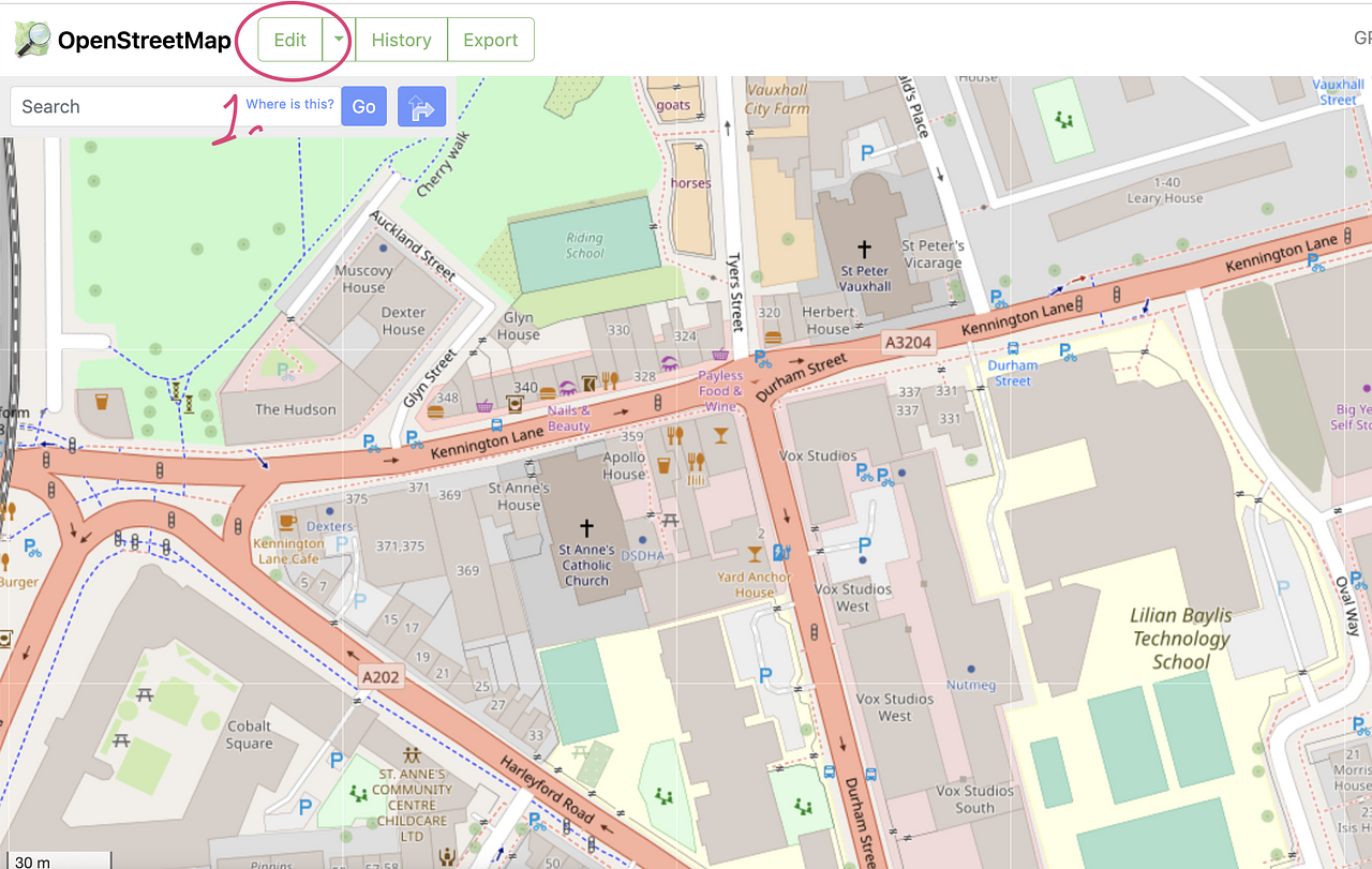
Open Online editor (openstreetmap.org - you will need to register and then log in to access it)
-
If you are new in editor I would recommend following this rules:
Avoid modifying existing buildings! (Except adding addresses)
Do not move, split any existing roads, underground features like electric cabels and etc. Even if you see on arial image that they are incorrect, they could be mapped this way on purpose. Raise a note with a question if you have doubt.
Avoid making a lot of changes on big areas: do several small changes in one area, save your work and only then switch to other areas
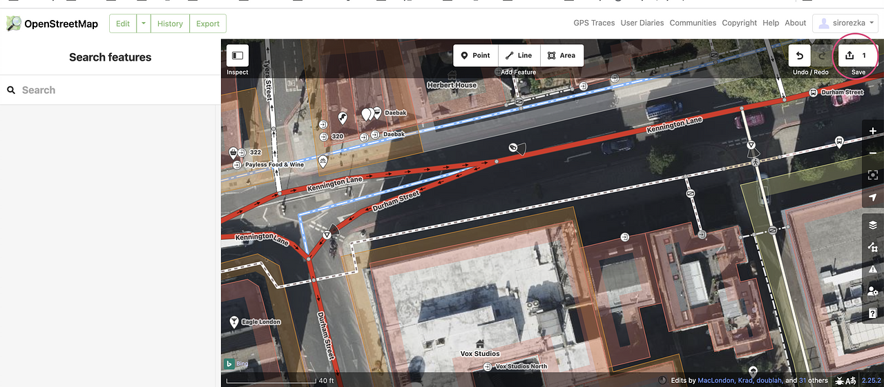
To create a camera use "point" feature. Select a point and place it somewhere on the map.
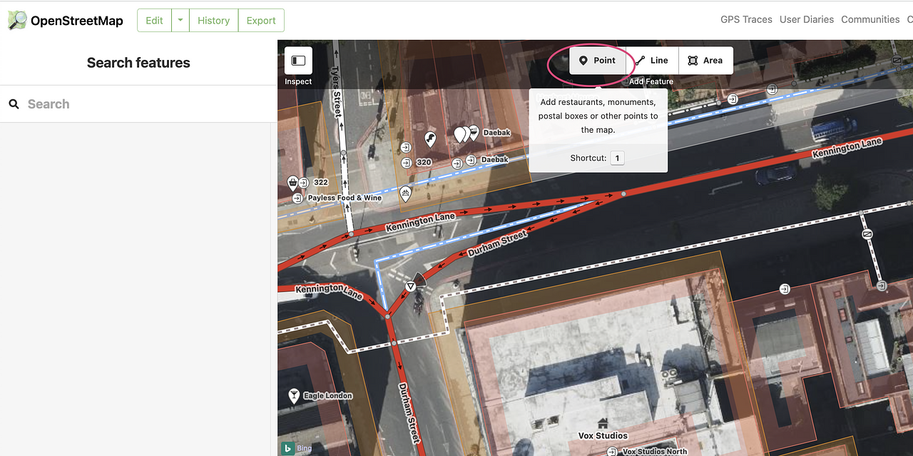
Press "point" button and then carefully click anywhere on the map. A new "bubble" icon will appear on the selected location. Keep in mind that you won't be able to place a point with 100% geo positional accuracy (current map will have erorr of several meters, aerial could have another 1-2 meters error and etc). So just add point in such a way so others will be able to find the mapped camera in the location.
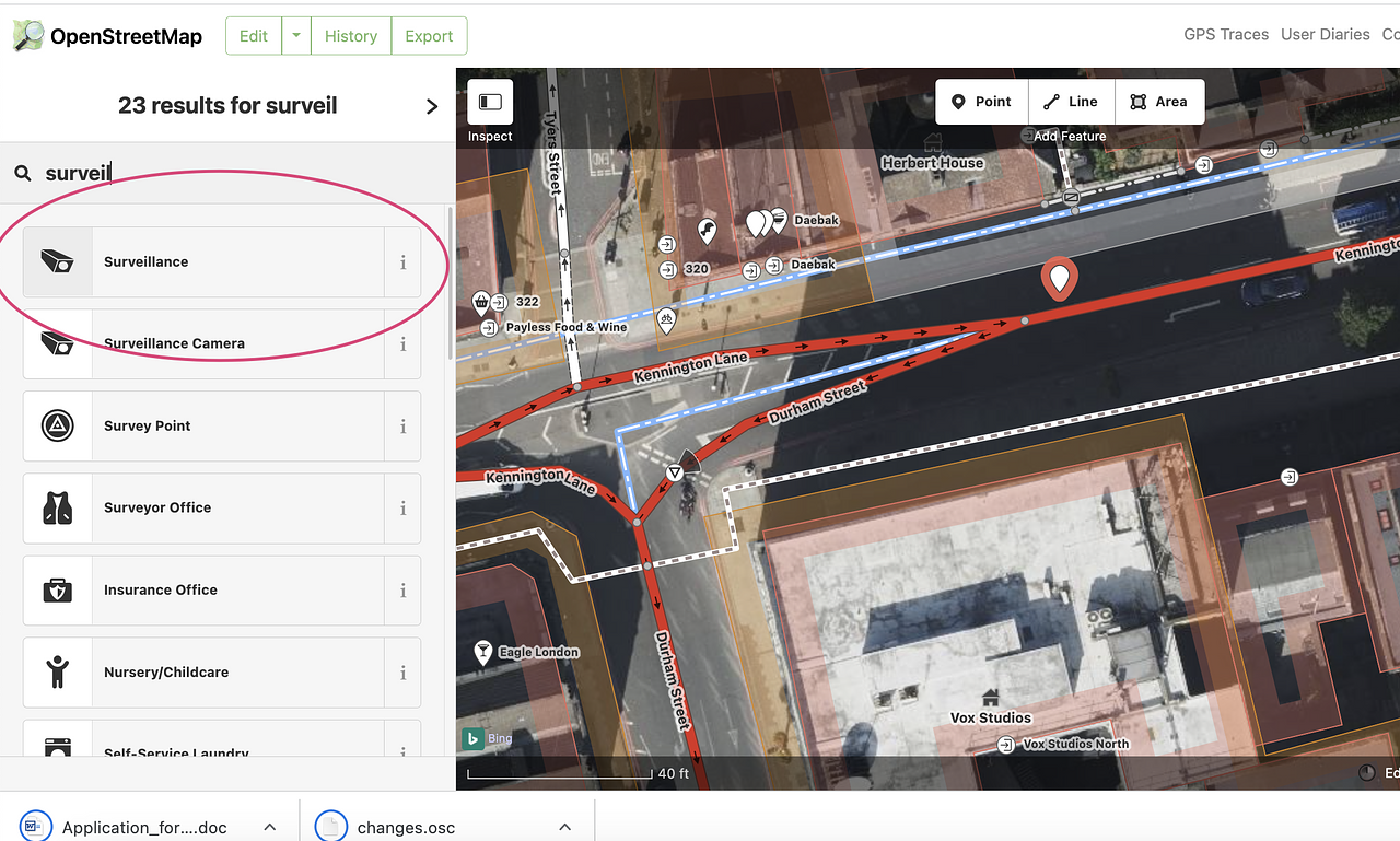
Select point type "Surveillance". (if the menu is hidden first press "inspect" button )
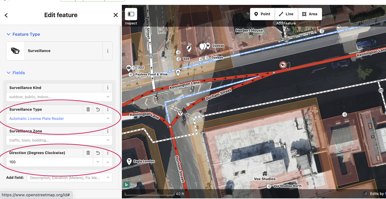
Select "Surveillance type" and "direction (if you know where the camera is facing). This is additional information, so it is ok if smth is missing.
You can add several cameras in one by one, before uploading your changes.
If you'll accidentally make an error use "undo" button:
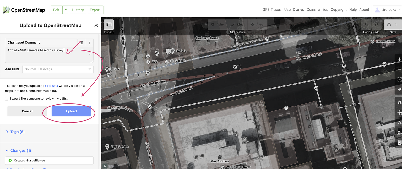
Finally save your changes by pressing "upload" button
By guidlines you need to add comment about your changes. You can write any text, other users often review changes, so they may pay attention to the text.
FYI:
Apps like MapsMe don't sync with Openstreetmap daily. On average they try to download new data one time per month. But at the end your changes will be visible maps like: Bing, OrganicMaps, MapsMe and etc
Sirorezka Wed 21 Jun 2023 11:26PM
With existing 800+ locations, because they already have coordinates, I can try and upload them programmaticaly using Python. Hopefully they won't clash a lot with already plotted cameras. Share the dataset with me, I'll figure out from there. (share the map, or excel table with lon/lat, "*.KMZ", or any other format).
Sirorezka Thu 22 Jun 2023 2:52PM
Also consider asking your question in https://community.openstreetmap.org/ Maybe they would recommend where it is allowed to quickly source more cameras. Basically there is a restriction on some data sources and publicly available photos (for example it is restricted to use any info from google maps)
Sirorezka · Tue 20 Jun 2023 3:34PM
Hi,
First of all there is a link between MapsMe and OSM:
as far as I know MapsMe is using data from OpenStreetMap (OSM). Thus if you add a note on MapsMe it will appear as note OSM. Then one of the mappers will add it when she will have time.
To check outstanding notes you could press "add note" button on OSM. This will allow you to add a note and to see all non-solved outstanding notes.
How to add new cameras to the map (we call this - adding a POI / point of interest):
Either create a note and wait till smn will add it
Use "Edit" button on Openstreetmap and add contribute as an editor - add cameras/pois that you are aware of.
Find somewhere dataset with coordinates of all cameras (longitude and latitude) and upload them programmatically using Python script (here community can help you with uploading a dataset)
Is it possible to launch massive crowdsourcing to find cameras?
Most probably it is not possible. Mapping community is very small and fragmented, each person is mapping objects of his own interest. Most active users are car drivers, cyclist and hikers - they have strongest cohort, but they contribute on topics of their interest.
Rather then crowdsourcing data collection you might consider developing Computer Vision solution. Ask smn you know to develop computer vision algorithm which will use bing street view data to find cameras on the roads.
But would like to hear others opinion on this...
One side note: opensource community switches from Maps.Me to OrganicMaps:
Maps.me is no longer an opensource project, it was bought by smn and now a commercial entity. Thus would recommend to start switching to MapsMe fork OrganicMaps (https://organicmaps.app/)